Climate, Environment, and Sustainability: Prerecorded presentation - Panel 2
Location: Online - Prerecorded
Presentation 1
JESSICA DARFLER, SURYA MAN, MARY KOUTURES, KYRA PRASAD, MAYUKHA TALINKI, KEVIN YANG, SAM YU, Jade Goegebuer, Bonny Bentzin, Carl Maida, and Cully Nordby
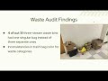
The CHS Waste Accountability Team aims to investigate non-hazardous waste in the Center for Health Sciences (CHS) building at UCLA, with a focus on identifying improper waste sorting patterns and barriers to effective waste diversion. We seek to understand the causes of improper waste sorting and how data can be used to educate CHS personnel. Previous research has shown improper waste sorting in large institutional and laboratory settings, and our team aims to explore how these issues occur specifically within CHS. This research will help fill key knowledge gaps and inform solutions that support UCLA Sustainability’s waste reduction and diversion goals.
Our quantitative methods include conducting visual waste audits on CHS floors and within laboratories. Our qualitative methods include interviews and surveys of CHS students and lab personnel to better understand waste management behaviors. We also plan to interview Thermo Fisher, UCLA’s primary laboratory supplier.
We have completed an initial set of waste audits on two CHS floors, generating data on waste diversion and contamination rates. We will continue data collection through Spring Quarter and use these findings to develop deliverables, including an informational handout and lab-specific waste sorting signage. These will be presented at a CHS open house in collaboration with UCLA Green Labs.
Presentation 2
RAN GUO, Karandeep Singh, Alex Hall
Stakeholders must understand climate-related disruptions to safeguard community well-being, particularly in sectors like reinsurance, which rely on accurate projections of temperature and precipitation extremes for risk management. Global Climate Models (GCMs) simulate large-scale atmospheric and oceanic dynamics but operate at coarse spatial resolutions – often over 200 kilometers – limiting their ability to capture local variability critical for impact assessment. Climate downscaling addresses this challenge by converting global-scale outputs into finer local data. Recent work has applied computer vision techniques to this problem, viewing coarse climate fields as “low-resolution images” and using convolutional neural networks (CNNs) to reconstruct fine-scale detail. This study extends that approach, applying machine learning–based super-resolution to improve climate data generation. Using paired satellite tiles from the 4x Satellite Image Super-Resolution Dataset (2-meter and 0.5-meter resolution), multiple CNN architectures were trained and evaluated using Peak Signal-to-Noise Ratio (PSNR) to assess image quality. Visualization results show improved recovery of spatial detail compared to baseline interpolation. Future work will scale this framework to larger geospatial datasets and integrate it with climate models using data from the National Center for Atmospheric Research (NCAR) to enhance fine-scale prediction and efficiency.
Presentation 3
MELISSA HUA, Claire Schollaert, Miriam Marlier
Wildfires in the United States (US) have increased in severity and size since the 1980s, partly driven by anthropogenic climate change. One consequence of more severe wildfire seasons is increased emissions of toxic pollutants such as fine particulate matter that are less than 2.5 micrometers in diameter (PM2.5), which pose significant public health risks. Previous research used satellite observations to estimate fire emissions, but data prior to the 2000s is lacking. DYNAFFOREST, a forest ecology model, simulates fire events starting from the 1950s, providing longer term estimates of regional fire activity than previously possible.
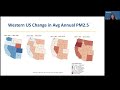
To investigate how the distribution of PM2.5 emissions in the western US has changed since 1951, we used outputs from historical DYNAFFOREST simulations. These included observed wildfire simulations from 1984 to 2023 and stochastic simulations of fire activity from the 1950s to the mid-1980s. Using these outputs, we compared PM2.5 emissions across the western United States from 1950 to 1984 with fires from 1985 to 2024, divided based on decadal intervals.
Results show that California consistently had the highest total and average emissions. Across the western US, all states experienced their highest levels of PM2.5 emissions within the last decade, but Oregon and Washington showed pronounced recent increases in PM2.5 emissions compared to other regions. Our results can inform more effective land management strategies by identifying regions impacted by increased wildfire-related air pollution.
Presentation 4
Ziqian Huang, Paul M. Ong
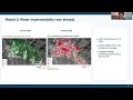
This study examines the role of sustainability in the Altadena reconstruction after the January 2025 Eaton fire by analyzing green coverage, water permeability, walkability, and solar permit adoption. Using Geographic Information Systems (GIS) methods, including NDVI and census-based comparison, the study compares these indicators before the fire (2024) and after the fire (2025 to 2026).
Qualitative analysis of reports from the Blue Ribbon Commission, UCLA Anderson School of Management, and the California Community Foundation suggests a lack of sustainability-focused policies across NGOs, the private sector, and government. Results show a significant decline in sustainability indicators following the fire, including reduced green cover and increased water-impermeability. Solar permit adoption rates also decreased after the fire, despite expectations that reconstruction would increase solar panel adoption. The use of Chi-square analysis suggests a statistically significant relationship between damage severity and solar permit adoption. It indicates the delays and barriers to sustainable reconstruction for heavily damaged units. Overall, findings suggest that the gap between sustainability goals in policy discussions and on-the-ground reconstruction sustainable indicators further emphasizes the need for stronger implementation of policies and strategies to support more sustainable reconstruction in post-fire Altadena.
Presentation 5
AISHWARYA MANGA, Sophie Michel, Ondine von Ehrenstein
Prenatal exposure to both environmental and conflict-related stressors can significantly impact maternal health, birth outcomes, and child development. Climate-related risks such as extreme heat, pollution, food and water insecurity, and infectious disease often intersect with conflict-related adversities like displacement, trauma, and malnutrition, especially in marginalized communities. This study examines the combined effects of these exposures during pregnancy through a structured literature review of recent peer-reviewed studies. We analyze how overlapping risks influence key outcomes such as gestational age, birth weight, infant morbidity, and neurodevelopment. Findings suggest that the intersection of maternal stress, immune activation, and disrupted prenatal environments amplifies biological and psychosocial vulnerability, particularly in resource-limited settings. These cumulative exposures may trigger lasting alterations in fetal programming, with implications for physical and mental health across the lifespan. Protective factors such as prenatal care access and community resilience may buffer some effects, but remain inconsistently available in high-risk regions. Understanding these cumulative risks is critical for informing global strategies that improve maternal-child health and promote resilience in vulnerable populations.
Presentation 6
CHLOE NG-LEE, Tierra Bills
Extreme heat has the highest mortality rate of any other weather-related event in the United States, and documented heat waves are becoming longer, more frequent, and more intense. Many studies have sought to understand how human health will be impacted by rising average temperatures, but very little have researched how extreme heat influences how people travel. Utilizing a statistical model, this project expands on past research to investigate how extreme heat alters travel behavior at the individual and community level in the cities of Los Angeles, Chicago, and Washington D.C. Research on how using different measures of heat, from ambient air temperature to thermal comfort, was done to understand if some measures of heat could better explain patterns in travel behavior, mode choice, and trip characteristics during extreme heat events. Additional analysis to understand if certain demographics' travel behavior may be disproportionately impacted by extreme heat events was also completed to reveal if inequity in transportation may be worsened by rising temperatures. With travel being a necessary component of everyday life, understanding how extreme heat events affect travel behavior and may also specifically impact disadvantaged populations based on race, gender, and age is pertinent to mitigating the effects of extreme heat and advancing environmental justice within urban areas.
Presentation 7
LIAN PHAM
The expansion of California’s goods-movement industry—encompassing transportation, warehousing, and logistics—has intensified environmental and labor inequities, particularly for Latino communities. Rising supply chain demands have driven this growth, along with the availability of more accessible, low-cost land. Logistics corridors—specialized transport routes that speed the movement of goods—have accelerated this expansion. This systematic review synthesizes existing literature and datasets to examine three interconnected domains impacted by this industry: environmental health, labor conditions, and zoning and land-use policy practices. Using environmental data such as CalEnviroScreen, a tool that identifies communities disproportionately burdened by pollution, along with public health and labor studies, this review shows how warehouses are concentrated in already overburdened communities. Environmental exposures faced by Latino residents are compounded by labor conditions shaped by low wages, temporary employment, and limited protections. In examining zoning and land-use policy, this review finds that zoning practices and regulatory gaps allow these environmental and labor patterns to persist. Together, these findings highlight how environmental and labor injustices are structurally linked, reinforcing inequities that sustain the industry while disproportionately harming Latino communities, and underscore the need for policies that address cumulative impacts, strengthen worker protections, and promote equitable land use.
Presentation 8
MADELEINE REAGAN
This research examines the effectiveness of third-party evaluation in helping community-led sustainability initiatives function more effectively by reporting measurable outcomes, guiding scope adaptation, and gaining unique participant insights through interviews. A key feature of community-led projects is a lack of funding and lack of organization, making self-evaluation difficult to accomplish. This project reviews the existing literature to see that historically, evaluation has been associated with increased impact, stakeholder involvement, community engagement, and efficiency in fund allocation. To test these findings, I joined a project evaluation team at the Luskin Center of Innovation (LCI) at UCLA, evaluating sites within the California Transformative Climate Communities program (TCC). TCC is an evolving, government and privately-funded initiative to invest in the ability of dozens of communities to develop sustainable practices. An evaluation team is necessary for reporting outcomes and keeping a broad project on track with funder goals. This project looks first-hand into interview data from community stakeholders and program beneficiaries to find that both parties benefit, and are recognizing the role of the evaluation team in improving the project outcomes. The evaluation methods exhibited by LCI’s TCC team show how evaluation can support community-led sustainability projects by improving communication between community members, participants, and funders.